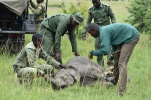
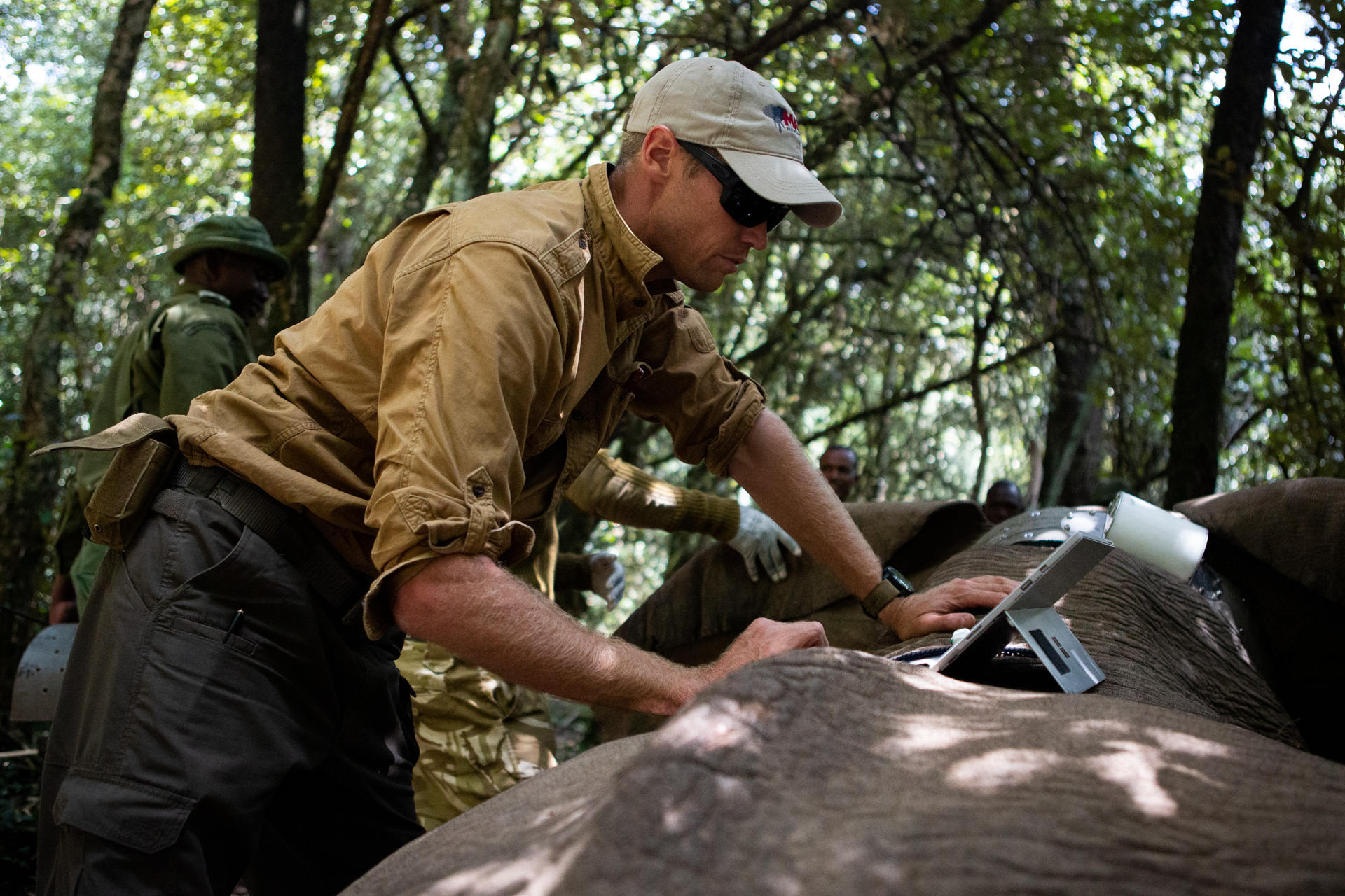
The MEP research department started the third quarter off with collaring a total of five elephants in July. The collars which were deployed will give us unique insight on elephant movements over a very large area from Southern Baringo, Mau, Nairobi, Mosiro and Loita. While all of these collaring operations are critical to MEP fulfilling our mission, the one that might be the most interesting took place on July 30: a bull elephant located in the Thogoto Forest was successfully collared on the western side of Nairobi with a population of over 3 million people. We received notice on July 28 that at least two elephants were spotted by the community in the heavily populated area of Dagoretti and KWS immediately responded by sending rangers to monitor their movements on the ground and keep both the elephants and nearby community safe. It was determined the best course of action was to collar this elephant in order to track his movements and collect data on where he came from, how he got there and why he may have ventured that close to Nairobi. The new bull is named “Hannibal” and will be closely monitored by MEP and KWS rangers on the ground and in real-time using the Save The Elephants Tracking App. After the collar was attached, Hannibal descended back down into the Rift Valley overnight and streaked 50 km in 24 hours. He’s now positioned in the Mosiro area south of Mount Suswa in a place we’ve previously recorded elephants.
We successfully collared Wangare in the Mau Forest.
MEP has been at forefront of human-elephant conflict mitigation, recording and characterizing conflict mitigation on EarthRanger. Our conflict mitigation work put us in front of the National Human Wildlife Conflict Compensation Task Force. The team sent to the Mara was chaired by Mr. Joseph Boinett and the meeting was a good forum to discuss some of the issues surrounding human wildlife conflict (HWC) compensation and mitigation. The appointed task force has a number of tasks, one of which was to get feedback from partners and stakeholders to help use past experiences to better develop the future national policies. The second meeting where MEP presented was held on the Lewa Wildlife Conservancy and a number of NGOs were able to share some of their experiences on mitigating HWC. Boinett and his inter-agency team was then able to join us on the second day. It was clear that instead of focusing on compensation we should focus on root causes. One of the items which was discussed as a tool in managing human-elephant conflict was collaring conflict individuals and sharing movement data in real time with key partners.
On July 3, MEP Tracking Manager Wilson Sairowua attended a meeting in the Mara on the proliferation of fencing and human infrastructure and presented the MEP spatial database tools for analyzing these data. The meeting, organized by Niel Anthony and Irene Amoke, was well attended. The meeting was also the launch of the One Mara Partnership Research Council that will help to be coordinate research in the Mara and encourage collaborations. Jully Sentenu is the coordinator of this exciting initiative and we look forward to working with OMP and other partners in the Mara. We will have a follow up meeting in September to focus specifically on corridors and connectivity in the Mara. At the beginning of September, Jake attended a census planning meeting to plan three upcoming elephant censuses: Nyakweri Forest Oct 2019, Maasai Mara May 2020 and Mau Forest 2020. Both the Mau and Nyakweri forest censuses will be dung counts as aerial counts are not feasible. The Mara count will be done by air. MEP will participate in all three by contributing ground teams to walk transects during the dung counts and will use the Karen Blixen Camp Trust 5Y-MEP to assist the aerial census, especially those areas in the hills that are more challenging with a fixed wing.
On July 26, MEP was called to work with KWS in the Suswa and Mosiro areas of the Rift Valley to react to human-elephant conflict that resulted in one human death and one injury. We deployed a collar onto a bull called ‘Napolean’ to better monitor movements in this region. Another bull called ‘Vasco’, was collared in a group at the north end of the Mau in the Chemesusu Forest and subsequently streaked east across the Rift Valley to Mukuyuni and Lake Solai. He is currently in a small forest patch near sisal plantations and we’re eager to see where he goes next as this was the first collared elephant to use this area.
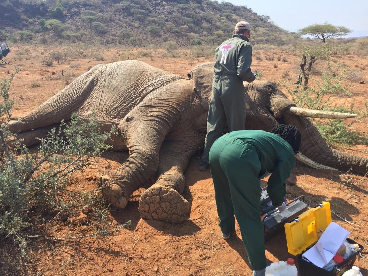
The collaring operation in Suswa.
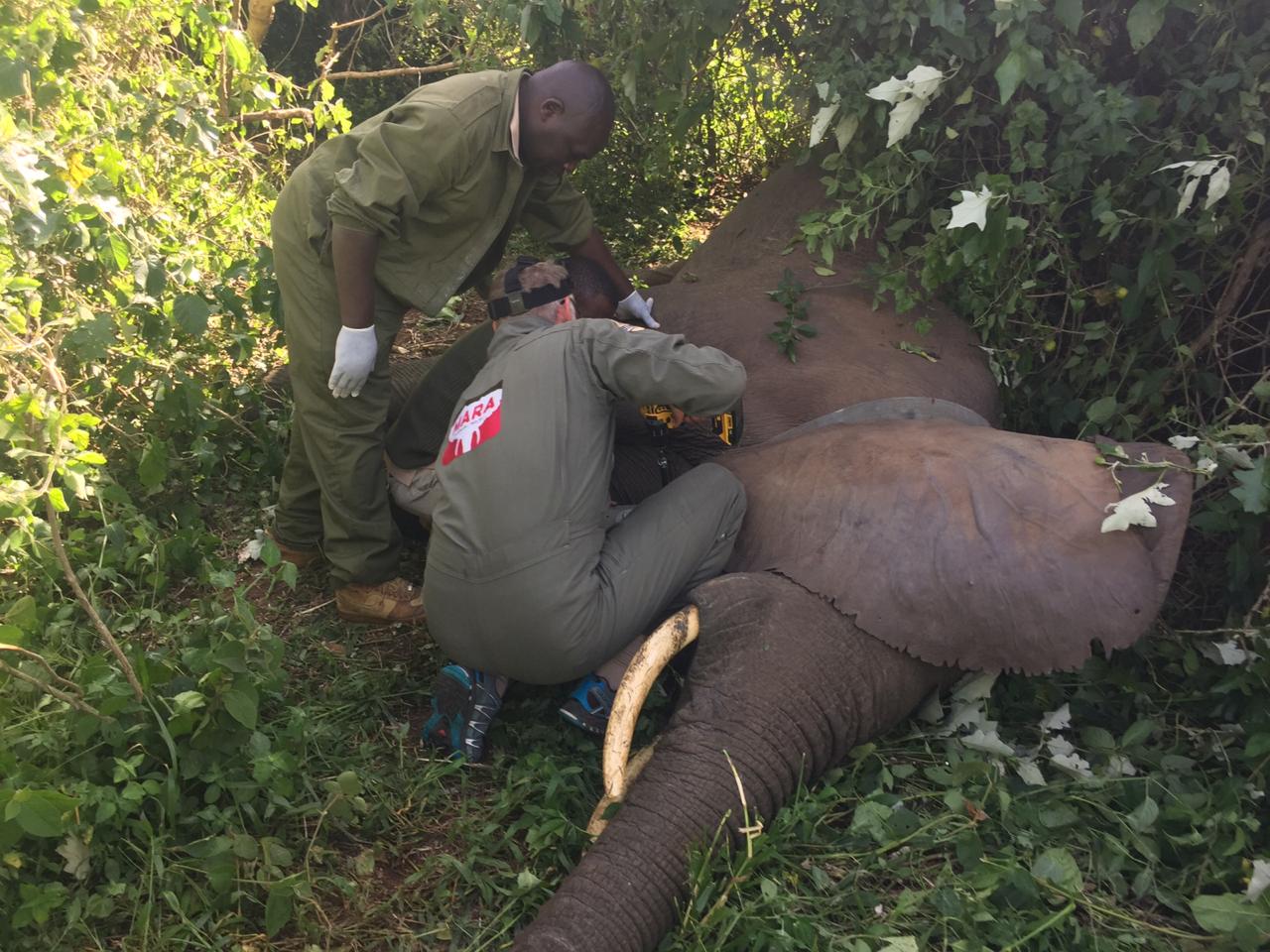
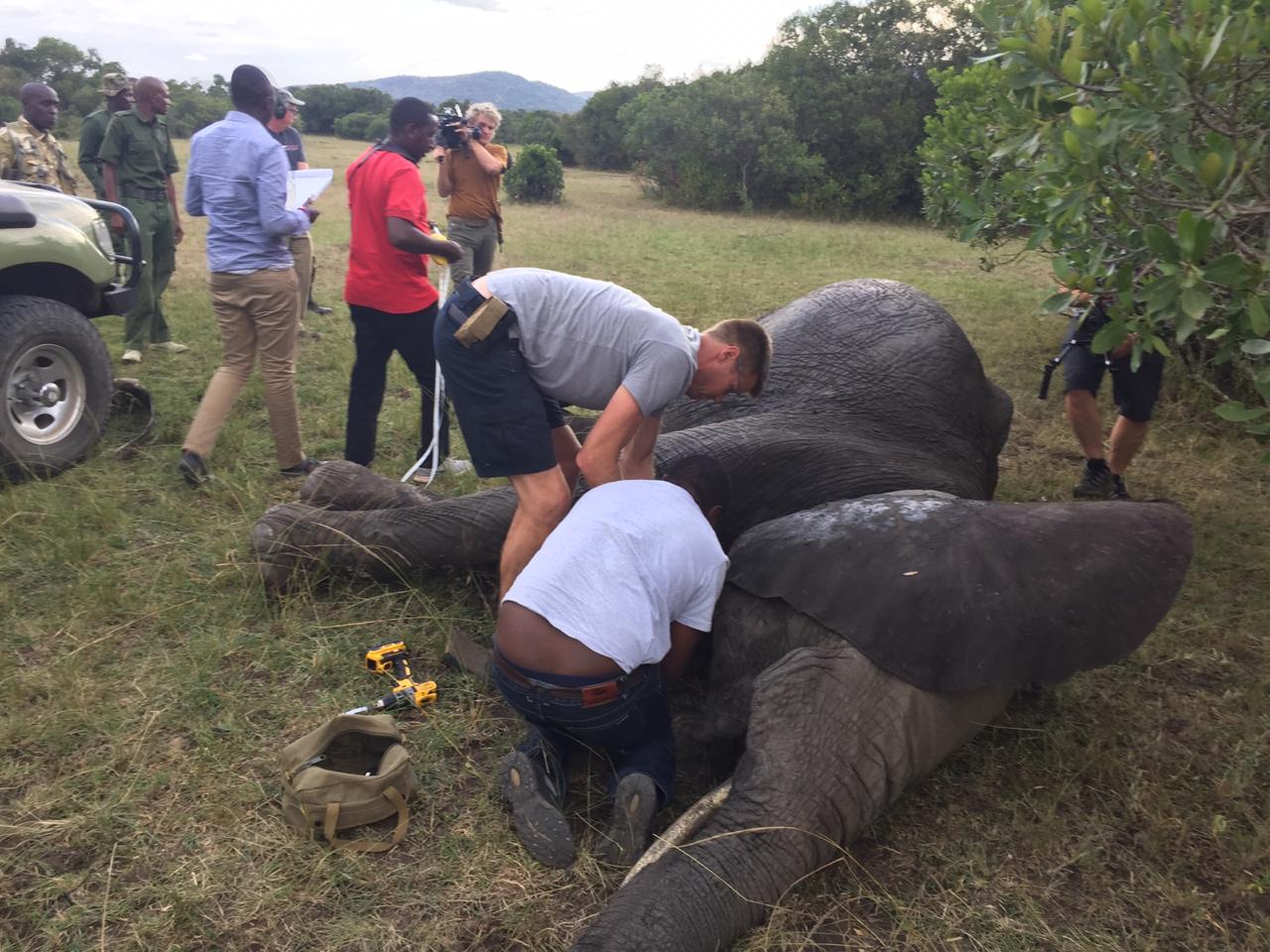 In August, MEP re-collared Ivy with her fourth collar. She’s one of MEP’s longest tracked individuals and also a notorious crop raider who has been continuously crop-raiding since we’ve tracked her, keeping our team based in Munyas on their feet with her almost nightly forays across the river. Recent results show that elephants can be categorized into three groups: those that rarely (if ever) crop-raid; those that do it sometimes; and those that are habitual raiders like Ivy. On August 20 we attached a collar generously sponsored by Angama Foundation onto an elephant called Fitz, whose data will continue on where the elephants Lucy’s and Tunai’s collars left off and help us to map out elephant range and use within the Nyakweri Forest. However, we were dismayed to see the levels of charcoal production and deforestation.
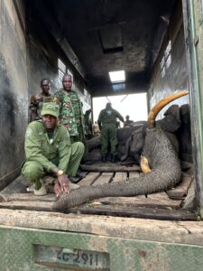
The successful collaring operation in the Nyakweri Forest.
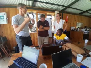
In August, MEP was very happy to host Dr. Izhak Shafran from Google. Izhak has a background in artificial intelligence-based audio signal processing. We’re hoping to collaborate with him in applying the latest AI methods to elephant movement analysis among several other conservation technology projects and will be visiting Google in early October. We also hosted Dr. Lydia Tiller from the elephant’s and bees project. Lydia, who did her PhD on elephant conflict in the Transmara, was able to show us the locations of camera traps she placed along a series of 24 pathways that elephants use to climb the escarpment into the Transmara. She captured and classified 680,000 images of elephants and other wildlife and we’re now working with Microsoft to develop a machine learning algorithm to automatically identify elephants in these camera trap photos. The data will give insight into the numbers of elephants moving in and out of the Transmara as well as group composition, which trails are most active, how long elephants stay up or down and how frequently they repeat their up-down escarpment movements. Shortly after the census meeting in September, Jake hosted Dr. Jared Stabach from the Smithsonian Institute Conservation Biology program for five days to kick off the first meeting of the One Mara Research Hub corridors working group. We looked at available wildebeest and elephant movement data along with infrastructure layers on fences and roads to plan an analytical approach to understand the effects of fencing on wildlife movement. Jared has also secured U.S. government resources to acquire satellite imagery across the Greater Mara Ecosystem that will aid our understanding of the human footprint in particular. In mid-September Marc and Jake hosted Frank and Saba from Save the Elephants for a weekend dedicated to working on the STE-MEP agreement relating to data sharing and laying out a framework for continued close collaboration between the organizations and which we are very excited about.
In September the new landDx (Landscape Dynamics) database went live on the Microsoft Azure cloud thanks to a grant from the AI4Earth programme and from the Esri Conservation Programme. The database is designed to track changes in landscape features such as fences over time. The data hosted in landDx will be made available to the One Mara Research Hub collaborators. MEP has worked to contribute several data layers already and we will continue to use the Njia mobile app for data collection on fencing and roads. In late September we started streaming data from approximately 30 wildebeest and zebra that have been collared by Grant Hopcraft in the Serengeti. These data now appear on the MEP EarthRanger system alongside our elephants and rangers. Although viewable using the Serengeti Tracker app developed by Grant, we wanted to be able to overlay the elephant and wildebeest data together and give insight into their contemporaneous space-use. One theory is that elephants high-tail it out of the Mara when the migration arrives and we want to test that theory quantitatively.